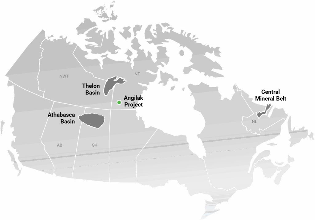
The Angilak Project
A high-grade uranium basin located in Nunavut with significant exploration potential
Project Overview
- The Angikuni Basin hosts some of the highest-grade uranium discoveries outside of the Athabasca Basin
- Subject to over ~$115M of investment since 1975
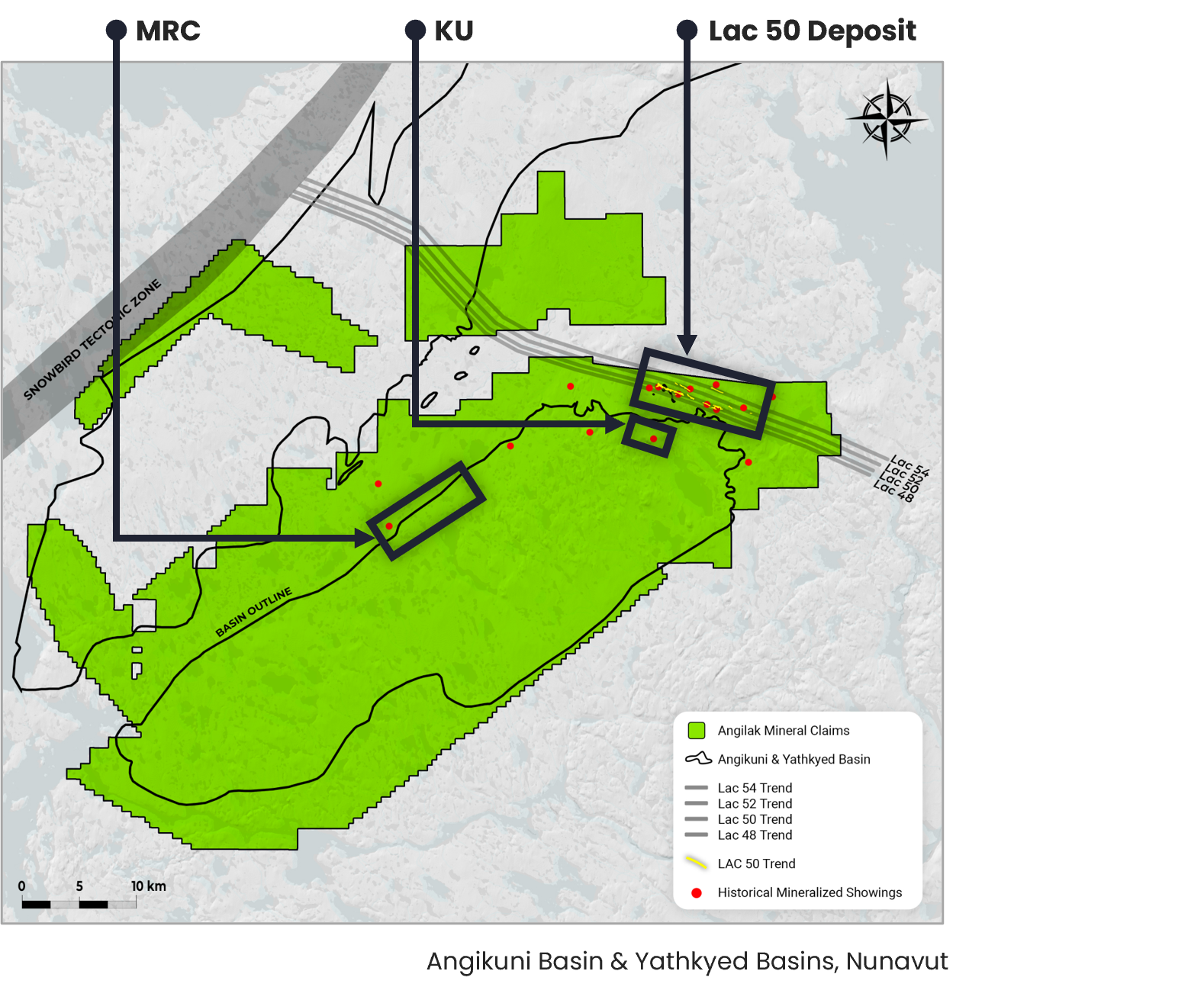
- Home to several multiple-km long corridors with confirmed uranium mineralization that run parallel to the Lac 50 Trend including, the Lac 48, Lac 52, and Lac 54 Trends
- Following ATHA’s 2024 Drill Program at Angilak, ATHA published the Lac 50 Deposit baseline conceptual exploration target ranging between 60.8Mlbs U3O8 and 98.2Mlbs U3O8, with an average grade range between 0.37% and 0.48% U3O8 respectively
- The stated potential quantity and grade is conceptual in nature, and there has been insufficient exploration to define a mineral resource and it is uncertain if further exploration will result in the target being delineated as a mineral resource. The conceptual target for further exploration is based on available diamond drillhole data including the 2024 drill program results, and the ranges of potential quantity and grade were derived from conceptual vein wireframes, drill core assays, grade interpolation and applied uncertainty ranges. The Angilak Project technical report can be accessed on the Company’s SEDAR+ profile at www.sedarplus.ca.
- Multiple regional discoveries along the 31km RIB-Nine Iron trend host hallmarks of large, high-grade, unconformity-style uranium deposits, comparable to world-class Athabasca Basin analogues
- 2025 exploration to date has resulted in five additional discoveries including the Mineralized RIB Corridor (“MRC”)
2024 Angilak Exploration Program Overview
25 diamond drill holes for a total of ~10,051m were completed in 2024 on the Angilak Project. The program successfully completed the following objectives:
Expand mineralization footprint at the Lac 50 Deposit
- All twelve holes drilled successfully intersected uranium mineralization outside of the previous deposit model
Test parallel structures to the Lac 50 Deposit
- All thirteen holes drilled successfully intersected new lenses of uranium mineralization
- Three prospective trends, all parallel to the Lac 50 Trend were identified
Surficial sampling, mapping and regional geophysics
- Program to delineate additional Lac 50 parallel mineralized corridors and identify prospective regional targets
For more information on the 2024 Exploration Program, view our November 25, 2024 press release here. To view the drill hole strip logs, inclusive of detailed assays for all drill holes completed during the 2024 Angilak Exploration Program, click here.
Angilak Project Area – 2025 Exploration Target Area (Black Rectangles), Mineralized RIB Corridor (Red Rectangles), & Mapped Historic Mineralized Showings1
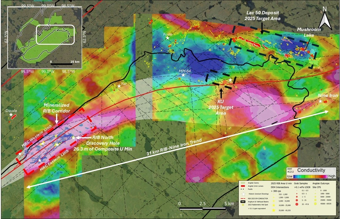
2025 Angilak Exploration Program – EM Inversion Model &Drill Collar Locations from Mineralized RIB Corridor
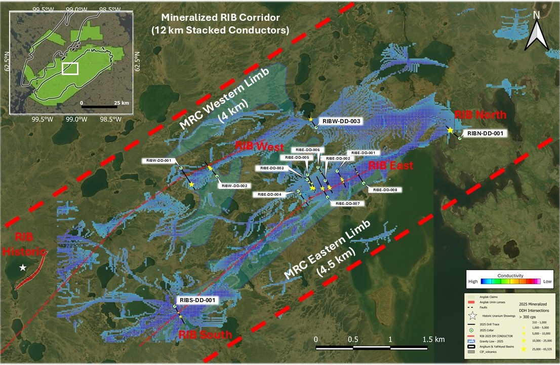
- Uranium mineralization along the eastern limb of the MRC has now been intersected across a 4.4 km long prospective graphitic structural corridor, extending from RIB South to RIB North.
- Along the parallel western limb of the MRC, the Company has intersected mineralization over an additional ~4.0 km prospective strike length from the historic RIB showing to RIBW-DD-003
- For further information on discoveries at RIB, see July 21, 2025 news release, September 18, 2025 news release, and September 23, 2025 news release.
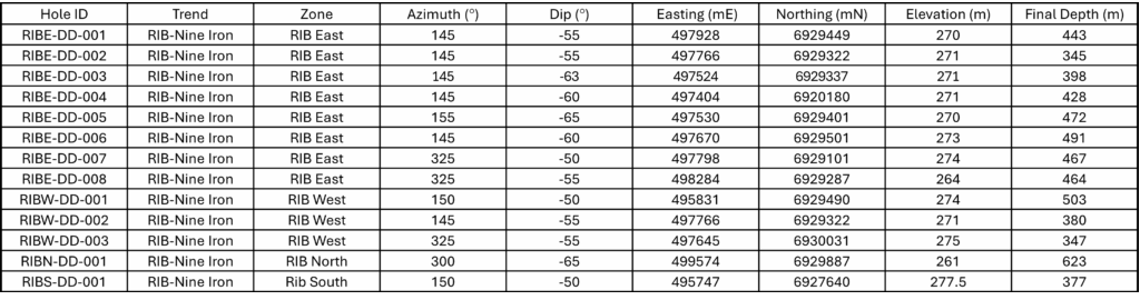
2025 Angilak Exploration Program Drill Collar Information
The Lac 50 Deposit
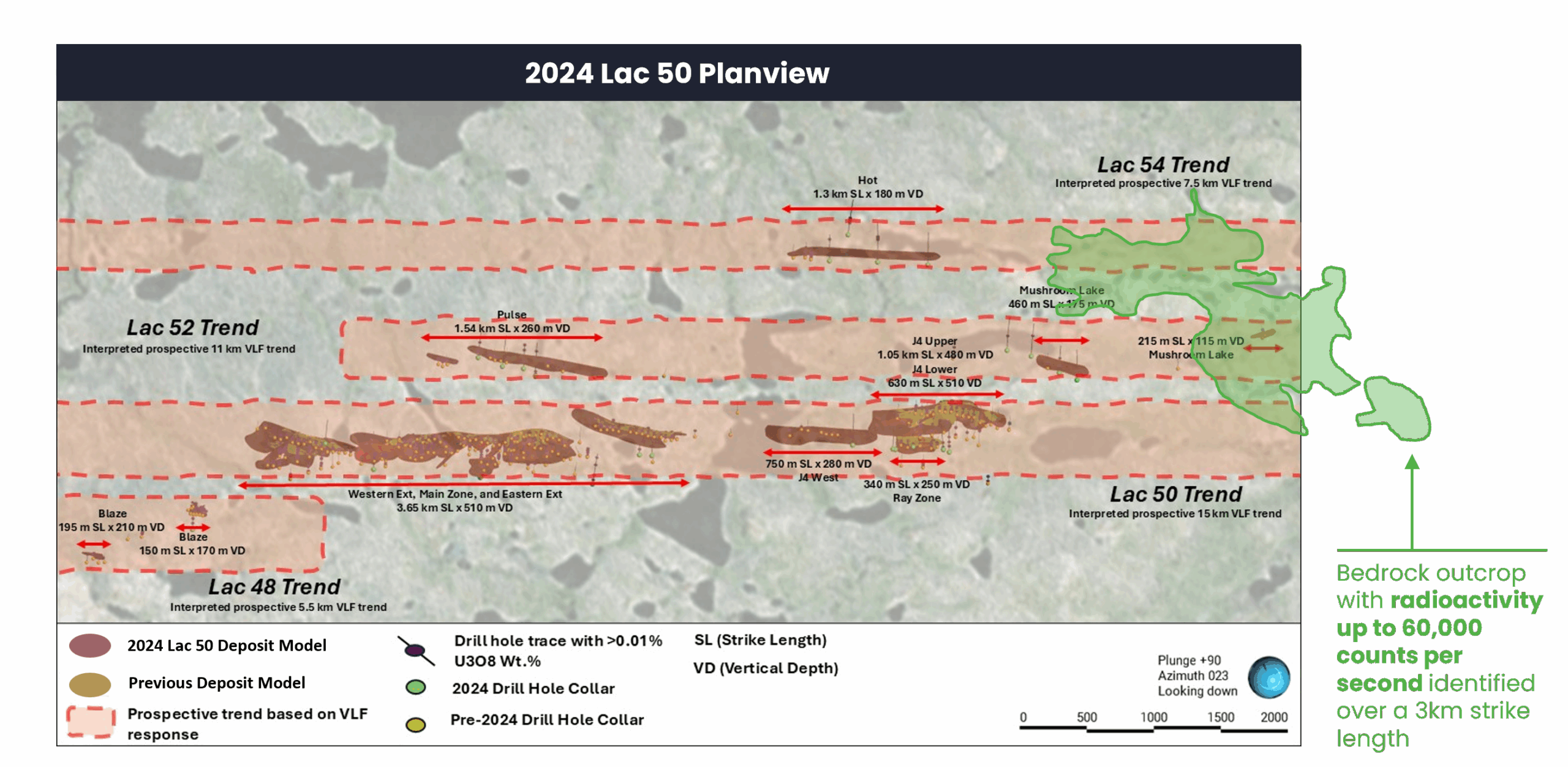
2024 Lac 50 Deposit Planview Schematic
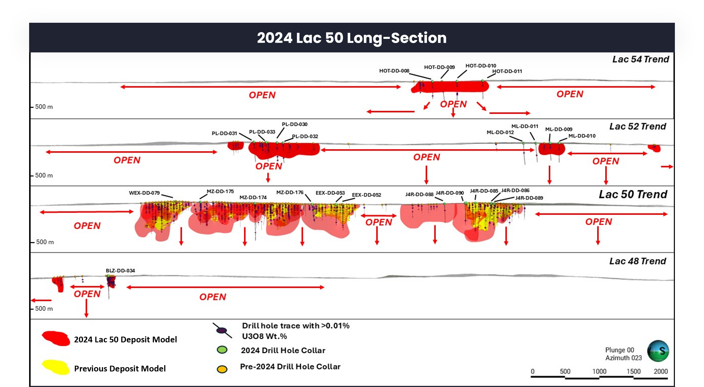
2024 Lac 50 Deposit Long-section Schematic
1HISTORICAL DRILLING AND OUTCROP SAMPLES
For additional information regarding ATHA’s Angilak project please refer to the Technical Report entitled “Technical Report on the Angilak Property, Nunavut, Canada” with an effective date of October 14, 2025 prepared by Matt Batty, MSc, P. Geo, who is a “qualified person” under NI 43-101, available under ATHA’s SEDAR+ profile at www.sedarplus.ca.
DOWNHOLE GAMMA PROBE
A Mount Sopris 40TGU-1000 Triple Gamma Geiger down hole probe was utilized for radiometric surveying.
The Company considers high-grade mineralization to be any interval with radioactivity derived from downhole gamma probe >10,000 CPS. The total gamma results provided were selected using an average cutoff of 500 CPS over intervals of 0.1 metre width. All drill intercepts are core width and true thickness is yet to be determined. Core samples are submitted to the Saskatchewan Research Council (SRC) Geoanalytical Laboratories in Saskatoon. The SRC facility is ISO/IEC 17025:2005 accredited by the Standards Council of Canada (scope of accreditation #537). The samples are analyzed for a multi-element suite using partial and total digestion inductively coupled plasma methods, for boron by Na2O2 fusion, and for uranium by fluorimetry.

Sign Up for Updates from ATHA Energy Corp
Sign up to receive the latest ATHA Energy Corp. updates directly to your inbox.